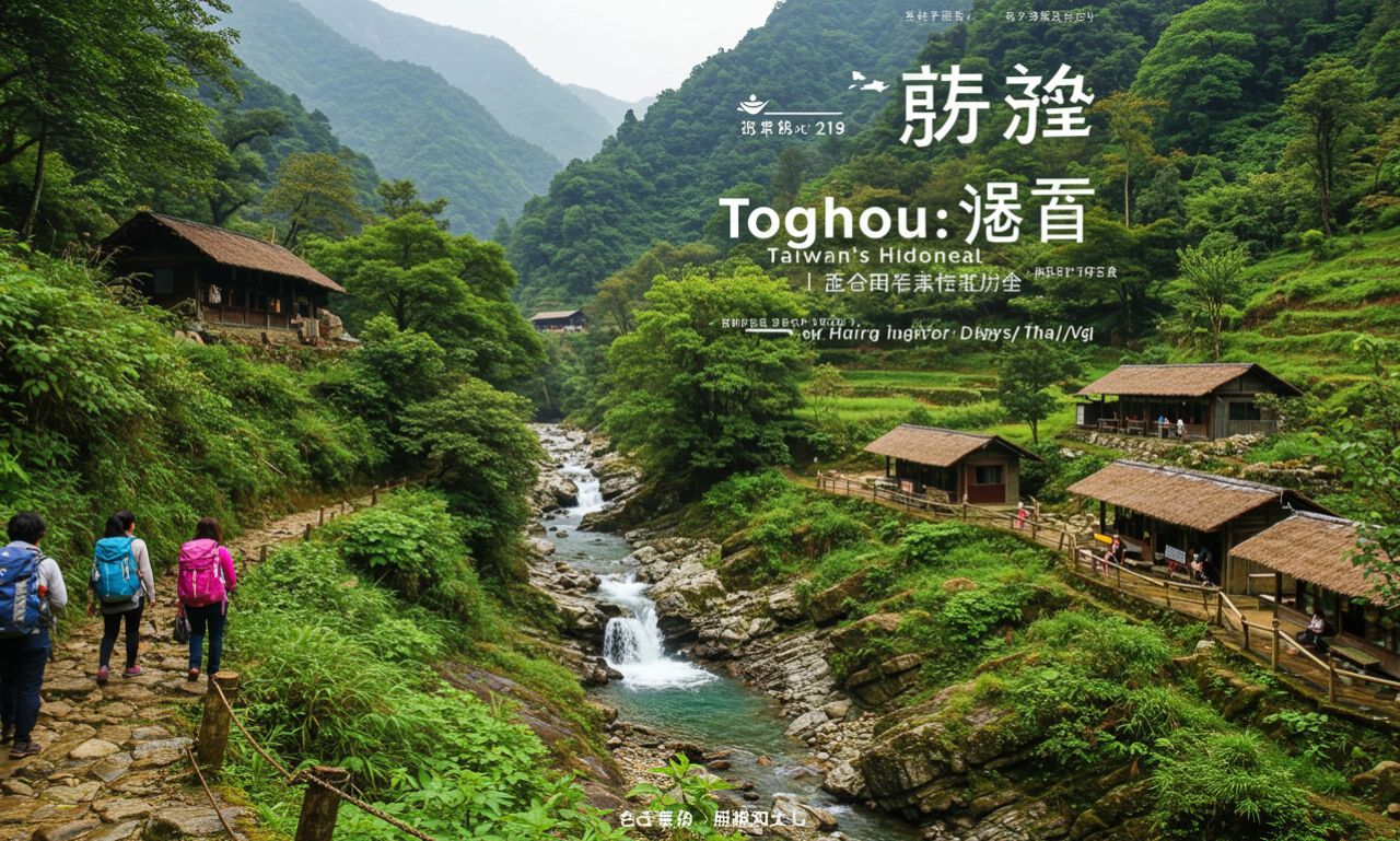
Tonghou (桶後, “behind the bucket”) refers to a geographic area in Taiwan, found in the Wulai District of New Taipei City and parts of Yilan County. It includes the Tonghou Traversing Trail (Tonghou Ancient Trail, 桶後越嶺古道), Tonghou River (桶後溪), and nearby peaks such as Mt. Hongludi.
The name “Tonghou” literally means “behind the barrel” or “behind the bucket,” where the “barrel” refers to Mt. Datong (大桶山). So Tonghou lies “behind” that mountain in terms of geography.
The area is lush, often remote, rich in forest, river scenery, and culture — especially indigenous Atayal tribe heritage.
Tonghou Trails & River Highlights
Tonghou Traversing Trail
One of the major features is the Tonghou Traversing Trail (Tonghou Ancient Trail), part of a network of old indigenous paths used by the Atayal people. These trails were originally hunting or commuting routes and were later modified during the Japanese colonial era for timber transport.
The Traversing Trail winds through forest, along riverbanks, crossing various terrain. It offers relatively moderate difficulty, making it suitable for hikers who want natural scenery and relaxation rather than intense mountaineering.
Tonghou River & Mt. Hongludi
Another striking feature is Tonghou River, the largest tributary of the Nanshi River, with origins near Mt. Hongludi (烘爐地山), which itself is about 1,166 meters high.
Hiking up Mt. Hongludi gives panoramic views of the surrounding mountains, forest canopy, and on clear days, vistas of Yilan Plain. Then descending toward Tonghou River offers the chance to relax by the river, swimming or wading, enjoying riverbanks, crossing shallow streams, and exploring side trails along water.
History & Cultural Significance
Tonghou trails are more than just natural beauty — they embody cultural, historical, and environmental heritage.
-
Indigenous Heritage: The Atayal tribe used these trails for generations, for hunting, gathering, connecting settlements. These trails form a core part of Atayal ancestral geography.
-
Colonial Era Changes: During Japanese rule in Taiwan, parts of these trails were converted into roads or logging paths. Timber transport was active, which altered terrain and trail structure.
-
Modern Restoration: Parts of these trails/traverses have been reopened to the public. After damage from natural disasters (e.g. typhoons), maintenance or closures occur; then re-opening brings interest from hikers, nature enthusiasts.
Tonghou Hiking Experience: What to Expect
Trail Difficulty & Terrain
Tonghou trails are generally moderate: forest roads, river crossings, some steep slopes (especially when climbing peaks like Mt. Hongludi). Terrain can be slippery or exposed in places. Proper footwear, awareness, some hiking experience helpful.
There are multiple junctions: connections to other trails such as to Mt. Sanjiaolun, or loops that combine several trails. Some sections include river or stream crossings, narrow paths.
Scenery & Wildlife
Lush forests (broad-leaved), dense vegetation, giant ferns, abundant river scenes — water flowing over rocks, clear pools, riverbanks ideal for rest or cooling off.
Wildlife includes forest birds, insects, possibly small mammals; the water ecology — fish, shrimp etc. — is healthy in many river sections.
Visually striking features: suspension bridges, river scars, mountain ridges, stone triangulation markers on peaks (like Mt. Hongludi).
Best Time to Visit & Permits
Weather matters: summer offers warm water, green landscapes, though heat and sudden rain may be issues. In rainy seasons, trails may be muddy or river levels high, riskier.
Access: some trails require permits, especially older ones or those in protected sections or indigenous lands. Check local government/hiking group notices.
Transport: no public transport directly to many trailheads. Typically, drive or hire a car/scooter to get close. Roads to some trailheads can be rough.
Tonghou Tips for Hikers & Tourists
-
Bring proper gear: sturdy hiking shoes with good grip, walking pole for river crossings/slippery slopes, rain jacket.
-
Water & Snacks: supply enough water; river access helps, but carry purification method. Food energy-dense; likely no stores along most trails.
-
Navigation: trails are marked at junctions, but maps / GPS helpful. Local hiking blogs helpful for recent conditions.
-
Safety: check weather forecasts; sudden downpours upstream can raise river levels. Be cautious on wet or steep side-hills.
-
Permits & Local Rules: respect indigenous land, obtain necessary permits, follow guidance from local authorities or park systems.
-
Preserve the environment: leave no trace, don’t litter, avoid damaging flora/fauna.
Challenges & Conservation Issues
-
Trail Stability: Typhoon damage and natural erosion degrade sections; managing repairs, closures is costly.
-
Environmental Impact: Increased foot traffic can threaten habitat, water quality. Need controlled visitor numbers, better waste management.
-
Access Issues: Remote nature makes transport and infrastructure hard; some paths prone to landslides.
-
Cultural Preservation: Ensuring indigenous Atayal culture is respected, trail names & usage info properly honours local history.
Future & Potential
-
Eco-Tourism Growth: As eco-tourism becomes more popular, Tonghou has potential to draw more domestic and international hikers. Good for local economies if managed well.
-
Trail Maintenance & Infrastructure: Better trail signage, improved safe crossings, small shelters or rest spots could improve visitor experience.
-
Digital Resources: More real-time condition updates (e.g. trail closures, river levels), apps for hikers.
-
Cultural Programs: Guided hikes with Atayal community involvement, interpretive signs about indigenous ecology/culture.
-
Sustainability Measures: Waste management, limiting environmental impact, monitoring wildlife, reforestation where needed.
Other Trails in Taiwan
Some comparisons:
-
Compared with high peaks (Alishan, Yushan etc.), Tonghou is less strenuous, more accessible for moderate hikers.
-
Compared to very popular trails (Jiufen, Taroko Gorge), Tonghou is quieter, less overcrowded, more “off the beaten path.”
-
River-hiking experiences are a plus: you get both mountain + water, which is especially appealing in summer.
Conclusion
Tonghou is an enchanting blend of Taiwanese natural beauty, indigenous culture, and hiking adventure. For anyone who loves rivers, forest canopy, moderate trails, or escaping into remote wilderness, Tonghou delivers. The area invites respect — of its environment, its people, its history — and rewards those who go prepared.
Whether for a single-day hike, a river dip, or peak view from Mt. Hongludi, Tonghou stands as a strong candidate for the next hiking destination to add to your list.